Have you ever woke up and said: “This Morning, I am going to run across a state!” You would think that I have but that actually has not been the case for me. It has been something of careful deliberation out on my standard training runs. I day-dream and mull over the logistics of such an effort before actually committing. And with this run, I was looking for something that I could do for motivation as a lead-up to my Hellgate 100k race. I had a tough year where races I hoped to perform well in, I did not. I struggled with just weird things that I normally have not dealt with and spent more time in the Pain Cave than actually feeling okay during a race as well as dealing with a nasty ankle injury that really was a blow to my running this Summer and Fall. My Run Across Rhode Island I was hoping could be that confidence boost for me. Being able to gain some momentum.
Rhode Island is not a big state. In fact, it is the smallest state in the country. Rhode Island is only 1,214 square miles while New Jersey is 8,723 square miles. I would like to run the North South Trail that is a 70+ mile trail that goes North to South in Rhode Island but I want to take more time in the logistics and planning as well as running it when hunting season is not going on as the course traverses wildlife management areas. For what Rhode Island lacks in size, it packs all types of diversity in such a small amount of space that you can quickly go from the hills and woods of the West, to the suburban and urban city life to the quaint ocean life in a short span of miles that no other place really can. That is something I truly love about Rhode Island. You get a lot of variety in such a short amount of miles.
Now being a resident of the Ocean State, it only felt fitting to look into a road route across the state. I started plugging in on Google Maps different points and saw a couple different options. With all of them, you start in Connecticut on the Western-side of the state before making the trek through the wilds of Rhode Island then into Providence and finishing in Massachusetts. What built my route was something others would want to do and one that was the easiest to navigate and the safest while also being a nice “Grand Tour” of the state in a 26 mile capacity. I settled on running on Route 44 the whole way into Downtown Providence and then running out finishing at some car dealerships called “Stateline Nissan” as well as an ice cream shop. The route below shows how the day unfolded and the route:
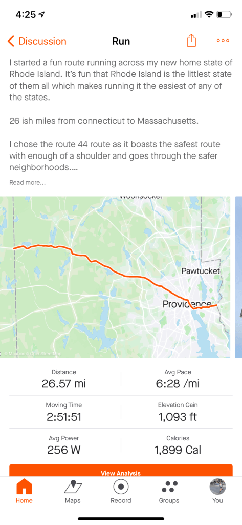
I like to run in as straight of lines as possible so this Route 44 path was excellent as you just stay on it all the way. The shoulders are manageable though runners do need to be careful early on but as you get closer to Providence, you can run on sidewalks the whole way through.
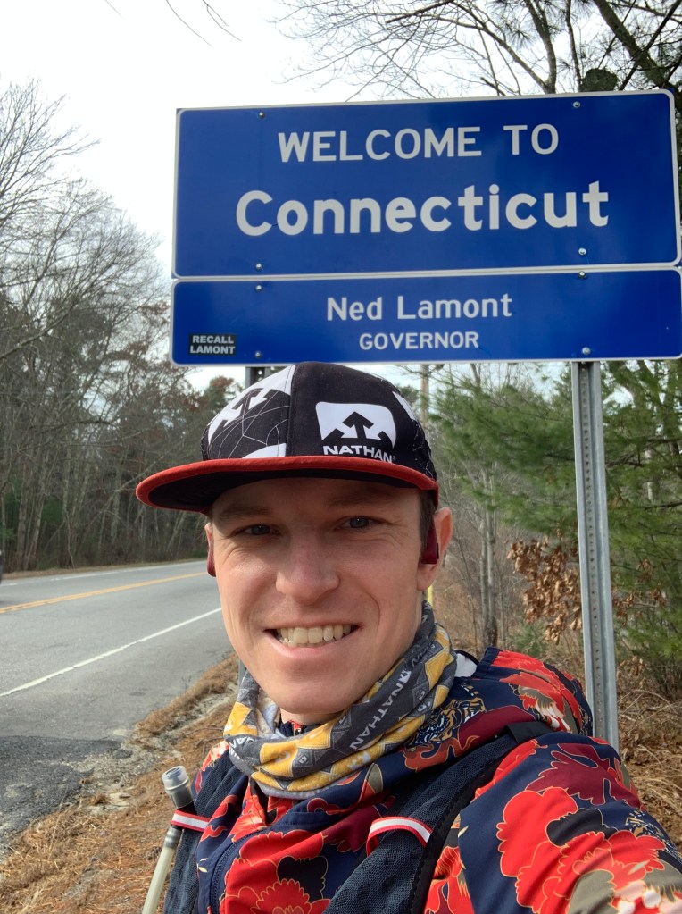
So on Thanksgiving morning, I started my epic run at the Connecticut sign out on Route 44. This area was up around 700ft elevation and right near the high point in Rhode Island as the temp was damp and cold-36 degrees. With the start of my Coros Apex watch, I was off on my grand adventure. I was using this “FKT” type of run as a slightly uptempo workout. I ran with only water with me as I have been training fasted since 2018 and have had great results doing this though I had a few gels with me if I needed them.
Off I set off and immediately I was running downhill and hitting some low 6 minute miles. Amongst the rolling terrain and hills that Rhode Island has throughout, I managed a strong effort and felt really good the whole way. I had a little low patch the last 2 miles but other than that, it was a glorious day. Instead of telling you how I felt throughout the whole run and a play by play-lets explore more about how the scenery around Rhode Island changes along this route as I think that was the real reason behind experiencing this run.
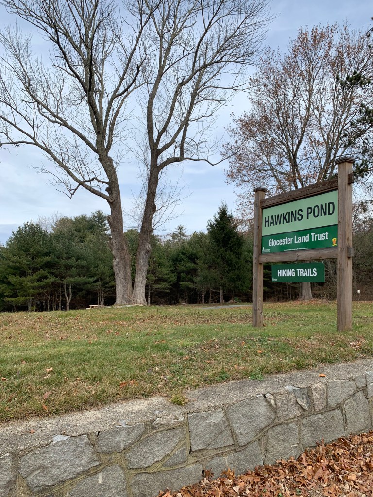


The first 8 miles of the run take you through the wooded and small villages in Western Rhode Island. This area has so many lakes, and deep woods that make it a nice and tranquil place to be. As I worked my way through Gloucester, I passed a country club here that is one of my customers and a really nice lake. Being the most rural section of the state, it is also the hilliest with nothing but long steep rollers. Lucky for me, it was more of a net downhill course so I would get a “Boston marathon” inspired type of course format. It was fun reading the street signs as I ran by and Puppy Path seemed to be the best one out there as it seems ducks are popular out on Puppy Path too!


Do you love Dunkin? Rhode Island has more Dunkin Doughnuts per capita than anywhere else. It is wild seeing the long lines of cars every morning waiting for their morning coffee as in NJ, this was never the case. Is Dunkin better here than other places? I think so, but it is still up for debate.
The route eventually moves into the suburbs of Providence. One of them being Smithfield. In the running route, you go by the main mall here with a Target and Dicks Sporting Goods, Panera etc. and this transitions leaving the heavily wooded areas of the West to the more central portion of the state. Smithfield is a nice place to be and as the miles ticked past half-way, I knew I was closing in on my old running spots. I soon hit Centredale and North Providence. It was great running through here as I have spent so many of my miles before buying our house learning about the area running through here. The terrain is now on side walks going through the little downtowns and the woods are now met more with homes, neighborhoods, and shopping centers. From here, we transition past the Rhode Island College and Lasalle Academy. There are still hills here but not as long but off of the course can be short and steep.
As you cross into Downtown Providence, the route goes by the state building which looks like a mini Whitehouse and then you cross by Roger Williams Park before running right through all of the shops in the valley from College Hill and Brown University to the left and to the right, the big buildings that make up the rest of Providence. It is a small city that has plenty of things going on and is to me, not too small nor too big. It is just the right size. And the city itself is really chill which is why I love running through it. People are always out just walking, biking, running and enjoying the city.


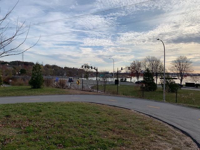
The route then transitions from the center of the city to the water and the bay. India point is an incredible place to be. With wonderful views of the bay, and the famous East Bay Bike Path, at this point in the run, you are 20+ miles in a in that home stretch and the views are amazing. The East Bay bike path takes you by the Narragansett Brewery over into East Providence.
I tried to switch gears here, but had felt a little tired and just grinded it in. As I moved through East Providence and then into Massachusetts, it was incredible to run across a whole state in just under 3 hours. Wow!
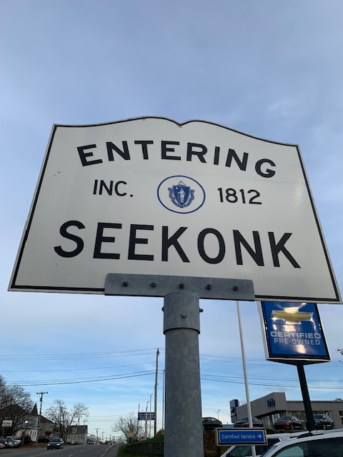


As I hit those signs, I knew I was done. It was an incredible way to start the Thanksgiving day and just what I needed.
Running to me is all about exploration and adventure just as much as running well and competing with competition. As I have gotten older, I have been looking to go after more adventurous races such as 200 milers and multi-day stage races. You do not always need an official race to not go out there and do your own homemade challenge. I love these for hard training days. Go out there and find your adventure!
If you have more questions about my run or would like me to maybe turn this into a race for other to do, let me know. Send me a message and you can follow along my journey on Instagram @colecrosby41
Gear Used for the Adventure:
Uglow Sport 5 inch short (This brand is sooooo good–light weight and seam-free for no chafe)
Nathan Vaporswift 4L pack and Speedraw Plus Insulated Handheld
